Similan Islands 4K: The Best Drone Shots You Must Capture
The Similan Islands stand as one of Thailand’s most breathtaking archipelagos, where crystal-clear turquoise waters meet pristine white sand beaches and towering granite boulders create dramatic landscapes. For drone enthusiasts and photographers seeking to capture nature’s artistry in stunning 4K resolution, these nine islands offer an unparalleled playground of aerial photography opportunities.
Located in the Andaman Sea, approximately 70 kilometers northwest of Phuket, the Similan Islands have earned their reputation as a UNESCO World Heritage site candidate. The name “Similan” derives from the Malay word “sembilan,” meaning nine, representing the original count of islands in this protected marine national park. Each island presents unique characteristics that translate beautifully through the lens of a high-quality drone camera.
Whether you’re a professional photographer, content creator, or simply someone who appreciates capturing extraordinary moments, the Similan Islands provide endless possibilities for creating jaw-dropping 4K footage that will leave viewers mesmerized.
Planning Your Similan Islands Drone Photography Adventure
Before launching your drone into the tropical skies above the Similan Islands, proper planning ensures you’ll capture the most spectacular footage while respecting local regulations and environmental conservation efforts. The best time to visit these islands runs from November through April, when the weather conditions are optimal and the national park remains open to visitors.
Understanding the local drone regulations is crucial for a successful photography expedition. Thailand requires drone registration for devices weighing over 250 grams, and flying within national parks requires special permits. Contact the Department of National Parks, Wildlife and Plant Conservation well in advance to secure necessary permissions for aerial photography within the Similan Islands National Park.
Weather conditions play a vital role in drone photography success. Morning hours typically offer the calmest winds and softest lighting, making them ideal for capturing smooth, cinematic footage. The golden hour just after sunrise provides warm, diffused lighting that enhances the natural colors of the turquoise waters and white sand beaches.
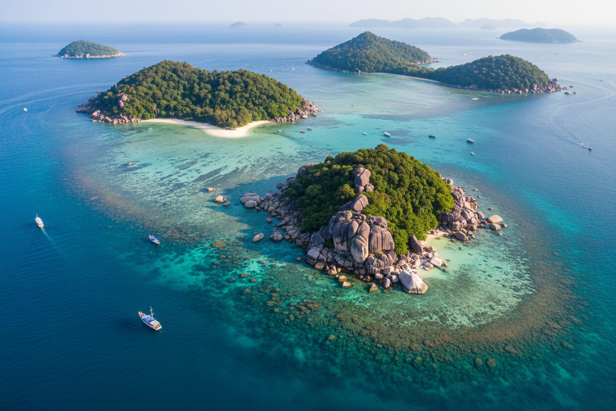
Ko Similan: The Crown Jewel of Aerial Photography
Ko Similan, the largest island in the archipelago, serves as the crown jewel for drone photographers seeking diverse and dramatic shots. The island’s most iconic feature, Sailing Rock, presents an extraordinary subject that looks absolutely stunning when captured from above in 4K resolution.
This massive granite boulder balances precariously on the island’s highest point, creating a natural sculpture that appears almost impossible when viewed from aerial perspectives. Position your drone at various altitudes to capture different compositions – wide shots that show the rock’s relationship to the surrounding landscape, and closer shots that emphasize its impressive scale and unique formation.
The western side of Ko Similan features pristine beaches with powder-soft white sand that creates beautiful contrast against the deep blue waters. Flying your drone along the coastline during different times of day reveals how the changing light transforms the beach’s appearance, from soft pastels during sunrise to vibrant blues and whites during midday.
Don’t overlook the island’s interior jungle canopy, which provides excellent opportunities for capturing the lush tropical vegetation that covers much of Ko Similan. These overhead shots showcase the incredible biodiversity and untouched nature that makes the Similan Islands so special.
Ko Payu: Underwater Worlds from Above
Ko Payu offers some of the most remarkable opportunities for capturing underwater coral formations from aerial perspectives. The island’s shallow, crystal-clear waters allow drone cameras to penetrate several meters below the surface, revealing vibrant coral gardens and marine life in stunning 4K detail.
The key to successful underwater aerial photography lies in understanding light penetration and water clarity. Morning hours provide the best conditions when the water remains calm and sunlight can penetrate deepest into the aquatic environment. Position your drone directly overhead and utilize the highest resolution settings to capture the intricate details of coral formations, sea fans, and the occasional passing school of tropical fish.
Ko Payu’s eastern shore features particularly impressive coral gardens that extend from the shoreline into deeper waters. These gradual transitions create natural leading lines in your compositions, drawing viewers’ eyes from the beach into the underwater wonderland beyond.
Experiment with different altitudes to achieve varying perspectives of the underwater landscape. Higher altitudes provide broader views that show the relationship between different coral formations, while lower flights capture more detailed shots of individual coral colonies and their vibrant colors.
Ko Bangu: Dramatic Rock Formations and Hidden Coves
Ko Bangu presents drone photographers with some of the most dramatic and photogenic rock formations in the entire Similan archipelago. The island’s rugged coastline features massive granite boulders that have been sculpted by millions of years of wind and water erosion, creating natural arches, caves, and unusual formations that look spectacular from aerial viewpoints.
The island’s most photographed feature is a natural rock arch that frames the turquoise waters beyond. This formation provides endless creative possibilities for drone photography, allowing you to fly through the arch for dynamic shots or position the drone to use the arch as a natural frame for the seascape beyond.
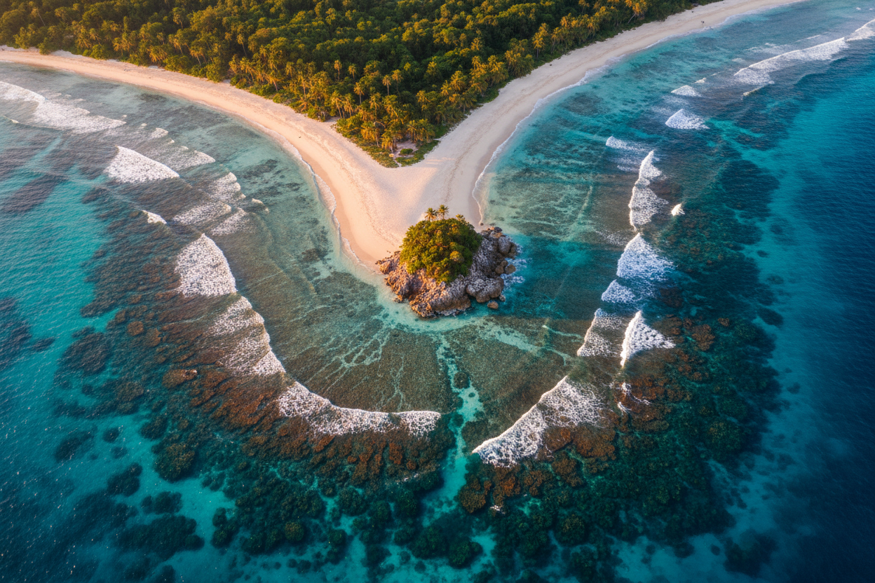
Hidden coves scattered around Ko Bangu’s coastline offer intimate scenes perfect for 4K capture. These secluded beaches, accessible only by boat or swimming, provide pristine settings where white sand meets crystal-clear water in perfect harmony. The contrast between the dark granite rocks and bright white sand creates striking compositions that translate beautifully in high-resolution footage.
For the most dramatic shots, consider capturing Ko Bangu during the golden hour when the warm light enhances the natural colors of the granite formations and creates long shadows that add depth and dimension to your aerial compositions.
Ko Miang: Twin Beaches and Tropical Paradise
Ko Miang, the second-largest island in the Similan chain, offers unique opportunities for capturing twin beaches that showcase the incredible diversity of coastal landscapes within a single frame. The island features two distinct beaches separated by a narrow strip of land, creating fascinating aerial compositions that highlight the geographic variety of the archipelago.
The western beach of Ko Miang stretches for nearly a kilometer, providing ample space for capturing long, sweeping shots that emphasize the scale and beauty of this tropical paradise. The beach’s gentle curve creates natural leading lines that guide viewers’ eyes through your compositions, while the consistent white sand and clear water provide clean, minimalist aesthetics perfect for 4K footage.
Ko Miang’s eastern shore presents a completely different character, with a smaller, more intimate beach nestled between rocky outcroppings. This contrast allows drone photographers to capture the island’s dual personality within a single flight session, showcasing both the grand scale and intimate details that make the Similan Islands so captivating.
The island’s interior features well-maintained nature trails that wind through tropical forest, providing opportunities for capturing the lush vegetation and diverse ecosystems that thrive on these protected islands. Overhead shots of the forest canopy reveal the incredible density and variety of plant life that contributes to the islands’ ecological significance.
Technical Tips for Capturing Stunning 4K Drone Footage
Achieving professional-quality 4K drone footage in the Similan Islands requires attention to technical details and camera settings that maximize the incredible natural beauty of this tropical paradise. Understanding your drone’s capabilities and limitations ensures you’ll capture the highest quality footage possible.
Shooting in 4K resolution at 30 frames per second provides the optimal balance between image quality and file size management. This frame rate captures smooth motion while maintaining the incredible detail that 4K resolution offers. For scenes with significant movement, such as waves breaking on the shore or boats moving through the water, consider increasing to 60fps for even smoother playback.
Manual camera settings give you complete control over exposure and color reproduction. In the bright tropical environment of the Similan Islands, maintaining detail in both highlights and shadows requires careful exposure management. Use your drone’s histogram to ensure you’re not clipping highlights in the bright white sand or losing detail in the darker areas of granite rock formations.
Polarizing filters prove invaluable when shooting over water, reducing glare and reflections while enhancing color saturation and contrast. These filters allow your drone camera to penetrate water surface reflections, revealing the underwater coral formations and marine life that make the Similan Islands so special.
Wind conditions significantly impact footage quality, particularly when flying at lower altitudes near the water surface. Monitor wind speeds and adjust your flying techniques accordingly. In moderate winds, slower, more deliberate movements produce smoother footage than quick, jerky motions that can result in shaky or unstable shots.
Composition Techniques for Aerial Island Photography
Mastering composition techniques specifically suited to aerial photography transforms good drone footage into exceptional visual storytelling that captures the essence and beauty of the Similan Islands. Understanding how traditional photography principles apply to drone work, while recognizing the unique opportunities that aerial perspectives provide, elevates your 4K footage to professional standards.
The rule of thirds remains as relevant in drone photography as in traditional ground-based work. When capturing the Similan Islands’ beaches and coastlines, position the horizon line along the upper or lower third of your frame rather than centering it. This creates more dynamic compositions and allows you to emphasize either the stunning underwater coral formations or the dramatic sky and cloud formations above.
Leading lines take on new significance in aerial photography, where natural features like coastlines, coral formations, and rock structures can guide viewers’ eyes through your compositions. The curved beaches of the Similan Islands provide excellent natural leading lines that draw attention to focal points within your frame, whether that’s a distinctive rock formation, a secluded cove, or the transition between shallow and deep water.
Symmetry and patterns become more apparent from aerial viewpoints, allowing you to capture the natural geometric beauty of the islands’ formations. The circular or oval shapes of many coral formations, the parallel lines created by wave patterns, and the symmetrical curves of beaches all provide opportunities for creating visually striking compositions that showcase the mathematical beauty inherent in nature.
Capturing Marine Life and Underwater Scenes
The crystal-clear waters surrounding the Similan Islands provide exceptional opportunities for capturing marine life and underwater scenes from aerial perspectives. This unique form of photography requires specific techniques and timing to achieve the best results in 4K resolution.
Timing plays a crucial role in underwater aerial photography success. Early morning hours offer the calmest water conditions and optimal light penetration, allowing your drone camera to capture details several meters below the surface. During these conditions, you can often spot and film large marine life such as manta rays, whale sharks, and schools of tropical fish as they move through the clear waters.
Water clarity varies throughout the day based on tidal movements, weather conditions, and marine activity. The period immediately following high tide typically provides the clearest water conditions, as sediment has had time to settle and water circulation brings in fresh, clear water from the open ocean.
When filming underwater scenes from above, maintain a steady hover and use slow, deliberate movements to avoid creating water disturbance that could reduce clarity or frighten marine life. The goal is to become an unobtrusive observer that captures natural behaviors and movements without impacting the marine environment.
Adjust your camera settings to account for the light filtering effects of water. Colors shift toward the blue spectrum as light penetrates deeper into the water, so consider adjusting white balance settings or plan to color-correct footage in post-production to restore natural colors and enhance the vibrancy of coral formations and marine life.
Best Times and Lighting Conditions for Drone Photography
Understanding the interplay between time of day, weather conditions, and lighting quality dramatically impacts the success of your Similan Islands drone photography expedition. The tropical location provides consistent lighting throughout the year, but subtle variations in timing can make the difference between good footage and extraordinary 4K captures.
The golden hour immediately following sunrise offers some of the most magical lighting conditions for aerial photography. During this time, the low-angle sunlight creates warm, soft illumination that enhances the natural colors of the turquoise waters and white sand beaches. The gentle light also creates subtle shadows that add depth and dimension to rock formations and coastal features.
Mid-morning hours, typically between 8 and 10 AM, provide excellent conditions for capturing underwater coral formations and marine life. The sun has risen high enough to penetrate deep into the water while maintaining manageable contrast levels that preserve detail in both bright and shadowed areas of your compositions.
Overcast conditions, while less dramatic than bright sunshine, offer unique advantages for drone photography. Cloud cover acts as a natural diffuser, creating even, soft lighting that reduces harsh shadows and allows for better detail retention in both highlights and shadows. These conditions are particularly effective for capturing the subtle color variations in coral formations and the gentle gradations of blue in the surrounding waters.
Sunset photography presents its own rewards, with warm golden light that transforms the entire seascape into a magical, ethereal environment. However, be prepared for more challenging flying conditions as afternoon thermal activity can create gusty winds that require more skilled piloting techniques.
Conclusion: Creating Lasting Memories Through Aerial Artistry
The Similan Islands represent one of the world’s premier destinations for drone photography, offering an incredible combination of pristine natural beauty, diverse landscapes, and crystal-clear waters that translate magnificently into stunning 4K footage. From the iconic Sailing Rock on Ko Similan to the hidden underwater coral gardens visible from aerial perspectives, these islands provide endless opportunities for creating breathtaking visual content.
Success in capturing the best drone shots of the Similan Islands comes from combining technical expertise with artistic vision, environmental awareness, and respect for this protected marine ecosystem. The time invested in planning, understanding local regulations, and mastering the technical aspects of 4K drone photography pays dividends in the form of extraordinary footage that captures the true essence of this tropical paradise.
Remember that the most compelling drone photography goes beyond simply documenting beautiful locations – it tells stories, evokes emotions, and shares the wonder of these incredible places with viewers around the world. The Similan Islands provide the perfect canvas for creating such impactful visual narratives that will inspire others to appreciate and protect these precious marine environments for future generations to enjoy and explore.
Leave a Reply